

Intelligent geospatial monitoring with InSAR technology
Discover
EOSAR MEXICO
Next-Generation Satellite Monitoring
We transform satellite data into secure decision-making.
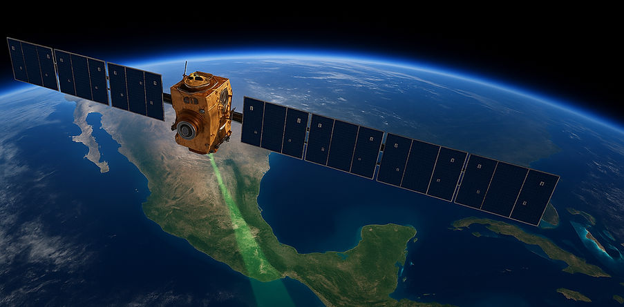
At EOSAR Mexico, we integrate geospatial science with advanced satellite technology to deliver accurate, affordable, and hands-off ground monitoring solutions. We are a consulting firm specializing in Synthetic Aperture Radar (InSAR) interferometry, which enables the remote detection and monitoring of millimeter-scale ground and infrastructure movements over time with a high level of reliability.
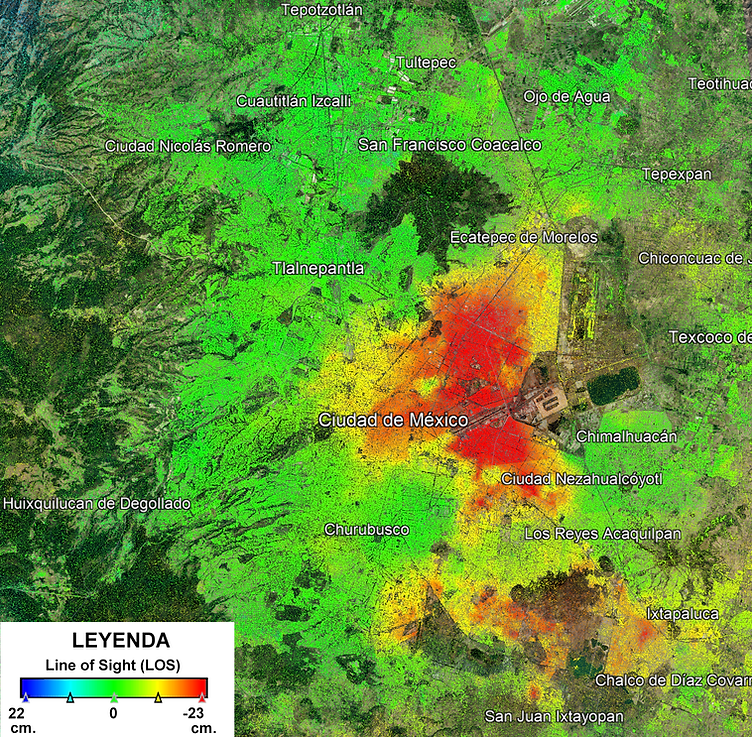
The detection of millimeter-scale surface movements allows for the identification and resolution of specific problems, such as subsidence in urban areas caused by the overexploitation of aquifers or geotectonic causes. It also facilitates the detection of areas at risk from natural hazards through the constant monitoring of minimal ground displacements, which is key to ensuring the stability of infrastructure projects and planned urban growth.
Our services are designed for sectors that require risk anticipation in situations that could spiral out of control, such as mining, energy, infrastructure, transportation, agriculture, watershed management, and civil protection.
What do we do?
-
High-resolution InSAR satellite monitoring.
-
Generation of terrain deformation maps.
-
Integration of InSAR monitoring with numerical analysis for modeling ground behavior under potential deformations or geomorphological changes.
-
Fusion of high-resolution InSAR, optical, and UAV data for the precise detection of deformations or changes in the terrain.
-
Early warnings.
-
Customized and understandable reports to facilitate strategic decision-making, with ongoing support, ensuring clarity, timely support, and confidence at every stage of the process.
-
InSAR results interpretation training for non-experts, training and knowledge transfer.
At EOSAR Mexico, we have been applying satellite data science to reduce operating costs, anticipate failures, and support strategic decisions with accurate and continuous information since 1992. We leverage the high availability of satellite data for reliable, flexible, and continuous monitoring, whether weekly, biweekly, monthly, quarterly, semiannually, and/or annually, providing reliable and large-scale monitoring.
As part of our processes, we integrate Early Warning systems based on continuous satellite monitoring, which allow us to identify deformation patterns before they become emergencies. Through multi-temporal InSAR analysis, we generate alerts to detect subsidence, landslides, and instability in slopes or structures, giving our clients the opportunity to act early, mitigate risks, and protect assets and critical infrastructure.
We connect satellites with real decisions
"No field sensors, no interruptions, no excuses. Just science applied to the land."
Whether for preventive monitoring or disaster response, at EOSAR Mexico we convert millions of data points into clear, visual, and actionable information.
Explore and get to know us
Solutions
At EOSAR Mexico, we transform satellite imagery into geotechnical intelligence for more accurate, safer, and more cost-effective decision-making. Using InSAR, we offer continuous ground monitoring with millimeter-level accuracy, enabling us to anticipate structural risks, optimize operations, and meet the highest safety and sustainability standards in mining, energy, and critical infrastructure.

Mining

Prevention and Management of Natural Disasters

Energy

Advanced Multisensor Geospatial Data Fusion

Infrastructure
About Us
Who are we?
EOSAR Mexico is a consulting firm specializing in terrain analysis and monitoring using advanced Synthetic Aperture Radar (InSAR) interferometry techniques, based on Earth Observation data. We combine scientific rigor, international experience, and a practical approach to offer solutions that anticipate risks, optimize decisions, and protect infrastructure, land, and the population.
Our mission is to transform complex satellite data into clear, actionable, and useful information for governments, businesses, and institutions facing challenges in strategic sectors such as mining, infrastructure, energy, disaster management, and the environment.

A network of scientific and technical collaboration
EOSAR Mexico is supported by a network of collaborators in Mexico and Germany, including specialists in remote sensing, geosciences, Geographic Information Systems, software development, and data visualization. This network allows us to address multidisciplinary projects with a comprehensive approach, from satellite data acquisition and processing to technical interpretation and user training.

Why EOSAR?
-
Experts in InSAR and applied geosciences.
-
A solid international track record of its team in science, cooperation and consulting.
-
Technical capacity to transform satellite data into concrete decisions.
-
Commitment to sustainable development, transparency, and social impact.
-
Local presence with a territorial focus in Mexico and Latin America.
At EOSAR Mexico , we promote accessible science by applying space technology to support responsible decisions.
We offer advanced InSAR capabilities, integrating methodologies with high quality standards, from a flexible and specialized Mexican company, with immediate, personalized, and local support.
Today, from Mexico, we put this experience at the service of governments, companies, and institutions that require reliable and advanced solutions to address complex geotechnical and territorial challenges.